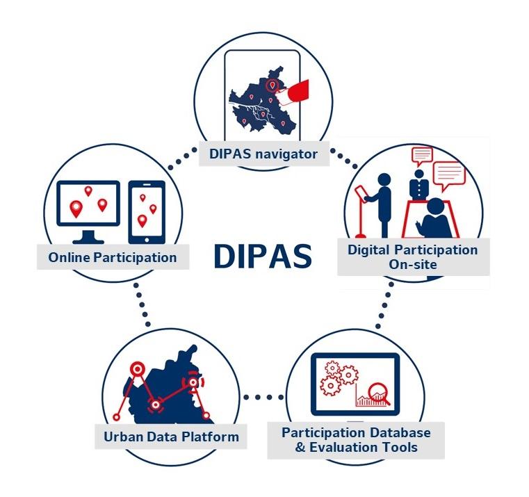
DIPAS combines Hamburg's online participation tool with digital planning tables to create an integrated digital system for citizen participation. With DIPAS, citizens can access digital maps, aerial images, plans, 3D models and geodata from home, on the go or at events and provide precisely localized feedback on planning projects.
DIPAS consists of an online and an on-site component as well as an overview component: the DIPAS navigator.
Do you want to try out DIPAS? This is possible in the DIPAS Demo Procedure.
All Hamburg DIPAS procedures can be found in the DIPAS navigator.
The Concept
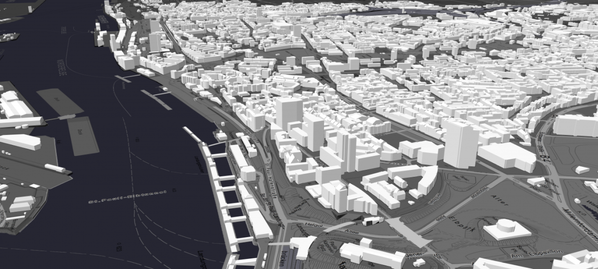
By using digital data tables (touch tables), the full potential of publicly accessible urban data and the digital city model can be utilized not only online, but also on site at public events. DIPAS can be used for a wide range of topics, ultimately for all planning procedures that have a clear spatial reference: urban development planning, green planning, traffic planning or even ISEK (integrated development concepts) or master plan procedures, whose topics and content can be easily accessed via maps and visualizations. The DIPAS system uses the variety of public geodata and thereby facilitates an informed discussion between experts and non-experts.
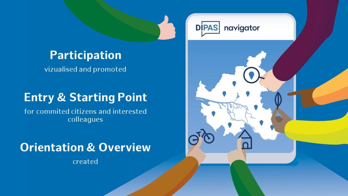
The DIPAS navigator automatically aggregates all process metadata via standardized interfaces at a city-wide level. The website of the navigator is therefore the entry and starting point for all committed citizens and interested colleagues. The DIPAS navigator provides orientation, makes participation visible and invites people to get involved.
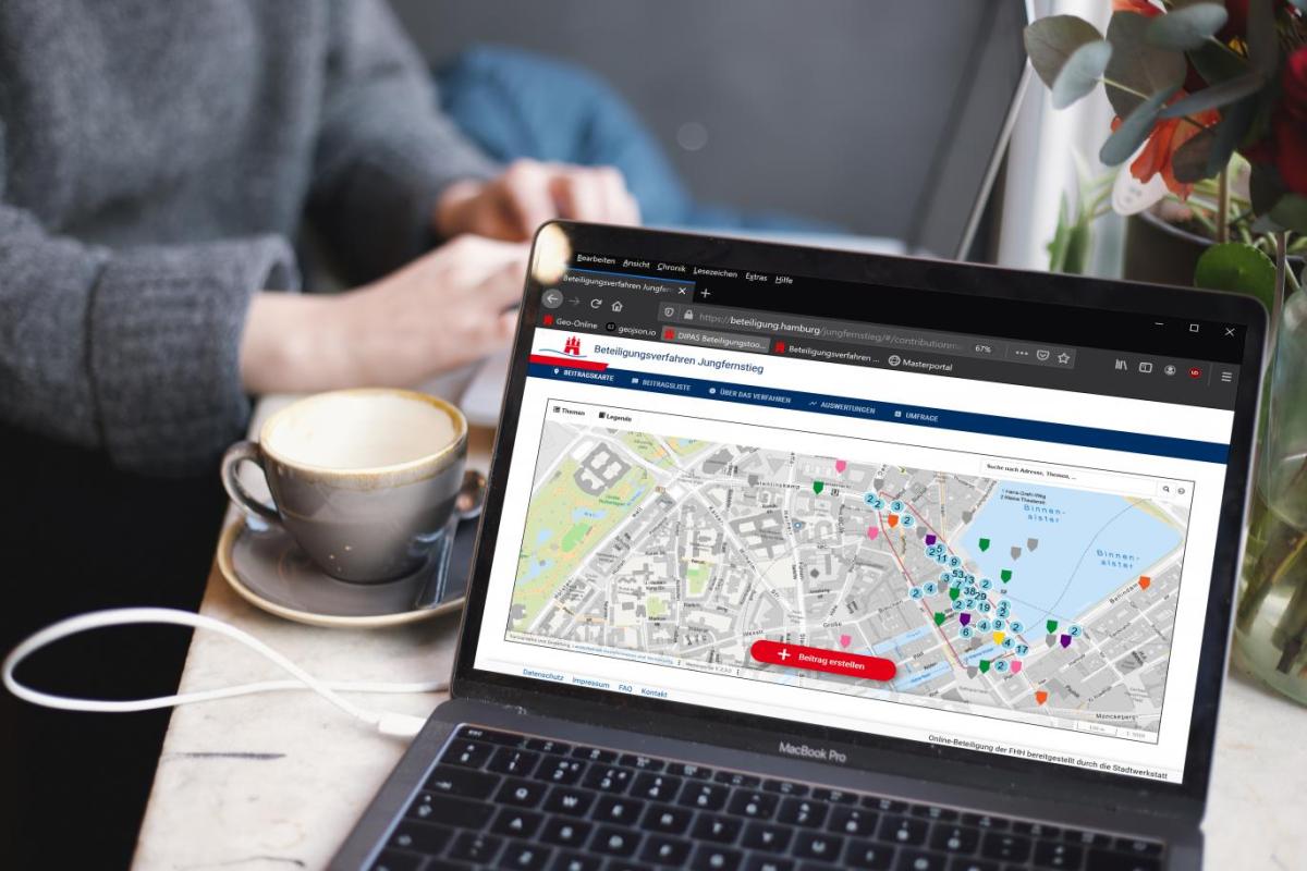
DIPAS Online Participation Tool – The Online Component
In order to equip all municipal planning authorities with a tool for online participation, the State Office for Geoinformation and Surveying (LGV) and the Stadtwerkstatt have developed their own digital participation tool based on open source software. This tool has been available to all authorities and companies in the City of Hamburg since January 2016. By the end of 2020, the online participation tool had been used in 55 procedures.
Its structure and functionality are based on the reference architecture for online participation of the National IT Planning Council. The geodata-based application enables citizens to submit comments, suggestions, questions and criticism on the city's plans via the internet. In this way, online participation generally forms a key element in complex multi-stage participation processes in which face-to-face formats and online elements are interlinked in a “cross-media” way.
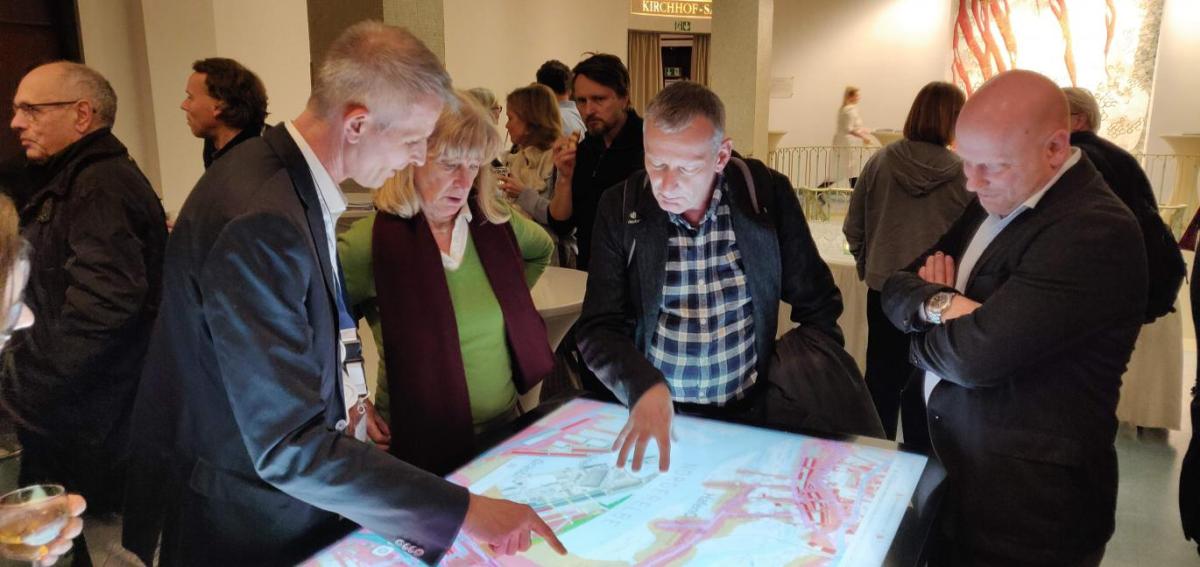
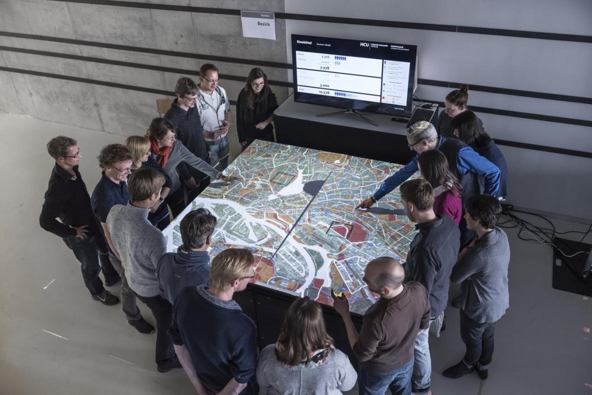
DIPAS Touchtable - The On-site Component
The second component of DIPAS is the digital participation tool for face-to-face events - the so-called Touchtable or On-site Component. This media-free digital system for citizen participation promotes and supports the exchange between experts and non-experts with the help of data-supported city models. The Touchtable is a mobile table that has a combined digital display and user interface (“multi-touch” functionality) and is operated with a high-performance laptop.
By using a map application specially developed for digital data tables (DIPAS table application), the full potential of urban geodata, digital models and simulations can now be used not only online, but also on site, e.g. at public events. During a moderated group discussion between citizens and those responsible for planning, the data table can be used to access the entire urban geodata infrastructure. Interactive base maps, such as a coloured city map, an aerial photograph or a simple black and white base map, form the basis for this.
DIPAS_stories - Stories on the Touchtable
DIPAS_stories is the latest tool in the DIPAS digital participation system and makes it possible for the first time to communicate urban planning framework conditions and planning projects with the help of spatial, geodata-based stories. Geodata-based specialist maps such as noise maps, digital development plans or 3D city models are contextualized as stories with texts, images and videos. The tool is currently in the beta phase and will initially be extensively tested and piloted.
Storytelling as a method of knowledge transfer has been successfully practised for many years, for example in the field of digital media. Now this method can also support the dialog between planners and the public through the interplay of interactive geodata and visually appealing media.
DIPAS navigator
The DIPAS navigator provides key figures and statistics at a city-wide level and at the same time allows users to dive into individual participation processes. Here, all interested parties can find out where, when and on which topics participation has taken place, which processes are currently open for participation and when local events are scheduled.
The DIPAS navigator provides orientation and offers a simple overview of digital participation in the city. It is the starting point and entry point for all interested parties. It makes civic participation visible and invites people to join.
The digital citizen service can be accessed by anyone via a browser on a PC or mobile device. Neither an app nor registration is necessary. This gives all interested parties the opportunity to find out about current participation opportunities and past processes in one central point. In future, it will also allow experts a comprehensive and up-to-date overview of the entire regional participation.
Click here to access the DIPAS navigator of the City of Hamburg

DIPAS_analytics
Support for the evaluation of large amounts of feedback: By using natural language processing (NLP, machine processing of natural language information), the steadily increasing number of digital contributions in DIPAS will be structured and processed more easily. For this, a digital toolbox for process managers was developed from the beginning of 2023 to the end of 2024. Like the DIPAS core software, this module will also be published as open source software and made available to the cities and municipalities that use DIPAS.
To ensure that the NLP analysis does not result in any distortions, the development of the algorithms is audited externally. This promotes the traceability of the evaluation and thus the integration into the implementation of public planning. However, rather than replacing people, the technology should support them. The review and assessment of the contributions by the experts responsible for the process remains crucial for the evaluation.
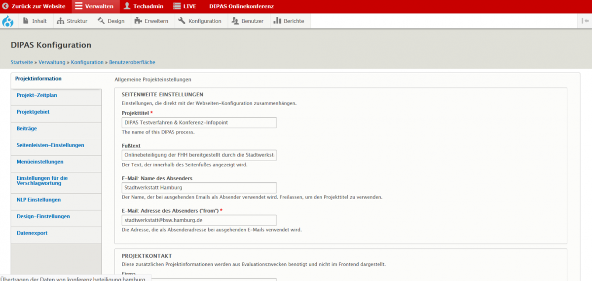
DIPAS Backend
The DIPAS backend is based on the content management system Drupal. It also includes an administration interface that enables project managers to administer their DIPAS participation procedure autonomously and easily.
- First, the technical administrator creates a one-time procedure template. In this template, all necessary basic settings that will be repeated for future procedures are set and default values are configured.
- From the procedure template, the technical administrator also prepares the individual procedure. To do this, all default values and basic settings are adapted to the specific requirements for the special procedure.
- Then the individual procedure template can be handed over to the person responsible for the project for filling in the content, configuring the various participation functions, moderating the participation contributions and exporting the data for further evaluation.
Background
As part of Hamburg's overarching digitalization offensive “Digital First”, the project “Digital Participation System”, short “DIPAS”, was launched in 2017. The aim of the project is to combine the online participation tool developed by the Ministry of Urban Development and Housing (BSW) and the State Office for Geoinformation and Surveying (LGV) with the CityScopes used by the CityScienceLab (CSL) at HafenCity University (HCU) to create an integrated digital system for citizen participation.
Following the Finding Places process, the BSW/Stadtwerkstatt was commissioned by the Hamburg Senate to adapt the CityScopes method and technology for urban planning in Hamburg. The core objective of DIPAS is to combine the efficiency of the CityScope planning tables as workshop tools with the reach of online participation and to integrate both with a powerful backend for data analysis.